Nearest Airport and City API
Get nearest airport data based on coordinates with our REST API
The Nearby Airports API helps you find airports and cities near any given location by using accurate latitude and longitude data. The location data is from Aviation Edge’s continuously updated airport and city databases. Simply provide a set of coordinates and a search radius, and the API returns all nearby airports and cities within that range—ideal for building location-based travel tools, logistics apps, or emergency response solutions.
- Type of location
- Coordinates
- City and airport identifiers (IATA, ICAO, ISO)
- Timezones
Data Included In The Nearby Airport and Cities API
Get detailed information about the nearby hub based on the coordinates input.
Travel & Booking Platforms: Suggest the nearest airports for faster flight searches.
Logistics & Cargo: Identify the closest airports for efficient route planning.
Emergency & Diversion Planning: Quickly locate alternative airports near any location.
Mapping & Navigation Apps: Enhance location-based services with nearby airport data.
Sources and Process
The Nearby Airports and Cities API database provides aggregated public information on the key transportation hubs within the circled area based on given coordinates.
We handle the entire data maintenance process for you—ensuring that the information stays accurate and up to date through regular automated updates and manual verification.
Nearby API Output - Developer information
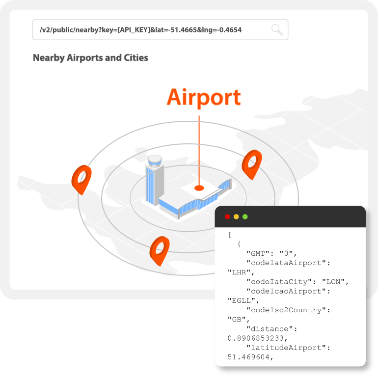
Airports and cities within a circular area based on any latitude and longitude points, and the distance (radius) in km:
&lng=122.6333&distance=90

Response Example
Airports and cities nearby

[{
“code”: “BUW”,
“icao”: “WAWB”,
“name”: “Baubau”,
“cityCode”: “BUW”,
“cityName”: “Baubau”,
“countryCode”: “ID”,
“countryName”: “Indonesia”,
“lat”: -5.466667,
“lng”: 122.63333,
“timezone”: “Asia/Makassar”,
“type”: “airport”,
“isRailRoad”: 0,
“isBusStation”: 0, “distance”: 0 },
{
“code”: “RAQ”,
“icao”: “WAWR”,
“name”: “Sugimanuru”,
“cityCode”: “RAQ”,
“cityName”: “Raha”,
“countryCode”: “ID”,
“countryName”: “Indonesia”,
“lat”: -4.916667,
“lng”: 122.583336,
“timezone”: “Asia/Makassar”,
“type”: “airport”,
“isRailRoad”: 0,
“isBusStation”: 0,
“distance”: 61404
}]
Nearest Airport API
The Nearby Airports API is a valuable tool for any travel, aviation, or logistics platform that relies on accurate, location-based services. By instantly identifying airports and cities near any set of coordinates by airport radius data, it helps users find the most convenient travel options, plan efficient routes, or respond quickly in time-sensitive situations such as diversions or emergencies. The airport geolocation API enhances the user experience by providing relevant results according to geographic proximity. When combined with real-time flight tracking, schedules, and airport data, it enables seamless, end-to-end travel solutions.
Aviation Edge provides a reliable API experience for all businesses and independent developers to get airport geolocation data.
Sign up today to get your API key in your email within a minute and benefit from Premium discounts and advantages.
Any questions? Aviation-Edge provides 24/7 email assistance with any requests with data, technical, feedback, payment and everything else. Feel free to contact us.
Your API key includes access to our complete aviation API catalog!
Find out more about the other API systems we offer by clicking the images below: