Satellite Tracker API
Get Your Real-time Satellite Tracker Data With Our API!
Aviation Edge Satellite Tracker API provides detailed, real-time data of satellites and objects orbiting around the Earth. The API covers real-time position information as well as many other details about the satellite such as name, NORAD ID, launch year, size, country of origin and more.
- Satellite Code
- Launch Date and Year
- Full satellite name
- Launch number and launch part
- Position
- ECI
- Classification
- TLE
Data included in the Satellite Tracker API
Get all orbiting satellite information in 1 API call or track individual satellites. You can also call all satellites based on the launch year or filter on your end based on the name if you are interested in certain satellites such as Starlink or ISS which are client favorites.
- Satellite Code: Designated NORAD code and international designator code.
- Launch Date and Year: Launch date in YYYY-MM-DD format. Launch year is also available as “LaunchYear”: YYYYY for filtering purposes.
- Full satellite name
- Launch number and launch part
- Position: Real-time orbital apogee, perigee and period values as well as altitude, latitude, longitude values and orbit and right ascension values
- ECI: Earth-centered inertial coordinates
- Classification
- TLE: Two-line Element Set (for more information on TLEs, you may visit our article here)
Sources and Process
Satellite Tracking data is collected via our data partners and aggregated from the satellites in a real-time manner. The data is presented to our clients in the form of fast, filterable and easy to access APIs for the perfect development experience.
Satellite Tracker API Output - Developer Information
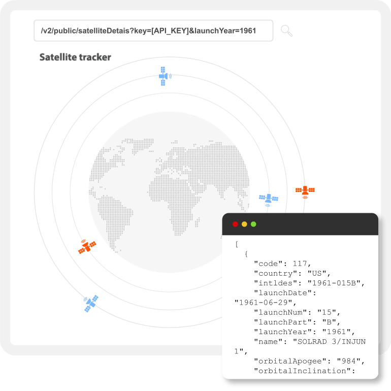
All on-orbit satellite information in one call:
https://aviation-edge.com/v2/public/satelliteDetails?key=[API_KEY]&limit=30000
Individual satellites based on NORAD number
https://aviation-edge.com/v2/public/satelliteDetails?key=[API_KEY]&code=408
Satellites based on launch year:
https://aviation-edge.com/v2/public/satelliteDetails?key=[API_KEY]&launchYear=1961
Individual satellites based on international designator (NSSDC ID) number:
https://aviation-edge.com/v2/public/satelliteDetails?key=[API_KEY]&intldes=1961-015EH
Filtering based on orbital apogee and perigee
https://aviation-edge.com/v2/public/satelliteDetails?key=[API_KEY]&orbitalapogee=1035

Response Example
NORAD number
Launch year
NSSDC ID


The Satellite Tracker API
With the rising popularity of aerospace companies such as SpaceX and Virgin (not to mention the one and only NASA), people, as well as businesses, are showing a significant interest in satellite tracking. The developments in the industry and remarkable rocket launches that are broadcasted live certainly raise the interest for developers looking to build products related to satellites. You may use the satellite tracker data to build visual maps to see which satellite is positioned where or even build a tool to track when the International Space Station (ISS) will fly over your head. Another use field of the data is to conduct aerospace analysis. Possibilities are endless. Get complete aviation data without having to rely on several different sources!
The interest in the aerospace industries continue. Getting information of every orbiting satellite is getting a bit tricky accordingly, with new satellites being launched every day. What most of the developers are looking for a single source with detailed and complete satellite tracking data. In this way, Aviation Edge is the most convenient source in the market for satellite tracking data. The information you get with APIs comes from our massive database.
But Aviation Edge’s data does not only cover satellites, it actually focuses on aviation data! Any Premium key will grant you access to our complete APIs. Feel free to use it for satellite tracking only or benefit from other amazing aviation APIs for different projects.
The APIs mainly include:
- Static Data: Stable data which does not frequently change, such as information regarding a certain airport and/or airline.
- Dynamic Data: Ever-changing data which is frequently in need of confirmation such as the flight-tracking, live airport schedules, satellite tracking.
Both the static data and the dynamic data are updated at all times in accordance with the information constantly gathered in our database.
Prefer the data as a file rather than via the API? The complete static data is available as separate standalone databases in Excel, SQL and CSV formats, too. All three are included in any purchase.
Clients are able to access and connect to the real time satellite data via the API key provided. The API key grants access to all satellite data live which can be displayed in clients’ applications, websites and/or other platforms of their choice.
After subscribing to one of the Premium plans seen here, you will receive your API key instantly via email. The API key is automatically activated and ready to use right away. The API key stays active as long a subscription does. For all available endpoints, visit our documentation here or use our quick GET tool to test the data.
Filter the data in any way you like to avoid receiving more information than needed for a simple and clear development experience.
Save the data on your end to create your own historical satellite tracking data for creating statistics or virtual maps.
Aviation Edge currently provides its clients with Satellite Tracker API, Real-Time Flight Tracker API, Nearby Service API, Routes API, Schedules API, Autocompletion Service API as dynamic data; and Historical Schedules API, Airlines API, Airplanes API, Airport API, City API, Country API and Taxes API regarding static data.
An active Premium API key lets you connected to our massive database which you can access any time. No daily or hourly restrictions to use your API calls – simply use up your calls in any quantity you like. If your monthly limit is not enough, it is always possible to upgrade to a higher plan. If you do not wish to worry about the call limits at all, feel free to contact anytime for the Unlimited option!
Aviation Edge provides a reliable experience for all businesses and individual developers with its super convenient APIs. In case you do not have previous experience with APIs, do not worry as getting used to the Aviation Edge APIs is very easy. Our team would be happy to answer your questions in case you have any along the way, too!
Please do not hesitate to contact us for any questions you may have.
Your Key includes all of our other Aviation APIs
Find out more about the other API systems we offer by clicking the images below: